INTERNATIONAL APPALACHIAN TRAIL
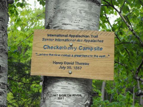
THOREAU’S CHECKERBERRY- TEA CAMPSITE & STAIR FALLS
by Earl Raymond, Maine Chapter IAT/SIA
The East Branch of Maine’s Penobscot River is famous for canoeing and fishing. Many hundreds of tourists and fishermen have made the trip from Matagamon Dam down to the Penobscot’s West Branch in East Millinocket. The river is little changed since Thoreau made his journey, especially from Grand Lake to Whetstone Bridge.
Two, routed, informational signs, both in T5-R8 WELS were installed on June 4, 2011, along the IAT. The Thoreau sign at the top of a steep bank on the East Branch of the Penobscot and the Stair Falls sign about one mile north of Haskell Rock along the trail.
Thoreau’s 1857 trip is well known and much has been written about it and his Indian guide, Polis.
The location of any of Thoreau’s campsites is of interest to many people. In this case, Thoreau describes a location that can only occur for a very short distance along the East Branch. In 2005 I decided to see if it was possible to locate this campsite by putting in at Matagamon Bridge and kayaking down the river the “some 5 miles“described by Thoreau. As it turned out, it is closer to three miles to the campsite’s location.
Thoreau wrote three pages about his stop here including Polis having found ”steel traps under a log, thirty or forty “, and lots of notes on flora.
Thoreau campsite 30 July 1857: Allegash & East Branch, chapter 8, pages 29-31
The description by Thoreau of his East Branch campsite on 30 July 1857, 154 years ago, is very detailed. “Having carried over the dam….. and glided down the stream in smooth but swift water for several miles…. we stopped at the first favorable shore, where there was a narrow gravelly beach on the western side, some five miles below the outlet of the lake. It was an interesting spot, where the river began to make a great bend to the east, and the last of the peculiar moose-faced Nerlumskeechticook mountains not far southwest of Grand Lake rose dark in the northwest a short distance behind …. but we could not see this without coming out upon the shore. “
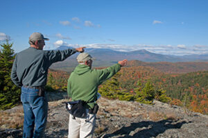
There is only one short area on the East Branch where this condition exists; it is at the beginning of what is now shown on maps as the “Oxbow”. The mountains can easily be seen from the river south of this area, although going downstream it requires turning around and facing up the river to confirm this.
These mountains are Billfish and Horse. Billfish is closer and very prominent; Horse is lower but shows a steeper face from both the land and the river. Billfish can be seen for a long way when coming up the river, around the bend of the Oxbow, because the view is looking up the channel in a northwesterly direction. Horse appears lower and to the east because it is farther away.
There is a stream coming in from the west, just up the river, that limits the area of the campsite because of the “bank four or five feet high”.
The woods (interminable forest) that Thoreau mentions are not here now. There was a camp in the vicinity that has been removed, and there is a” bank four or five feet high.” There is also a gravel road along the river at this point. Billfish can be seen from the location of the sign.
Thoreau called this Checkerberry-tea Camp because the Indian, Polis, made some pretty good tea from the Checkerberry (Gaultheria procumbens) by dropping a little bunch of it tied up with cedar bark into the kettle.
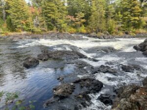
The next day Thoreau continued down the river and writes of smooth but swift water, which it is in the Oxbow, but never mentions Stair Falls that are less than a mile downstream and very prominent. The falls would not have required a portage in midsummer. After Stair Falls are: Haskell Rock Pitch, Pond Pitch, Grand Pitch, Hulling Machine Falls, and Bowlin Falls, before Thoreau’s next campsite. “We had heard of a Grand Fall on this stream, and thought that each fall we came to must be it, but after christening several in succession we gave up the search. There were more Grand or Petty Falls than I can remember.”
Thoreau’s next campsite (July 31.) was below the mouth of Wassataquoik Stream. “We had passed the Wassataquoik without perceiving it.”—–“camped about a mile above Hunt’s, which is on the east bank—“
STAIR FALLS
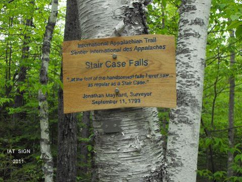
The Stair Falls sign is located on the IAT about one mile north of Haskell Rock. There is a good road/path from the sign leading one mile to the falls.
The first written record that we have of the falls is in the 1793 survey Field Book of Jonathan Maynard. Maynard was engaged by Massachusetts (Land Committee) along with Park Holland to survey the Penobscot River and lay out a line 6 miles east and parallel to the river. This six mile strip was to be reserved for the Indians.
JULY 30, 1793
“Left home and go to Boston, on my way to the Eastward on a Survey with Capt Park Holland where we receive our instructions from the Land Committee and Provisions for the Voyage and continue in town until the 4th of August “
Maynard and Holland sailed for the Penobscot River, proceeded up the river in a small schooner, and on the 8th day of August arrived at a place called Canduskeeg or Bangor. At the head of tide they made Quarters with Col J. Eddy, engaged our men for the survey, and were sworn by Justice Eddy. On the 13th they stopped at Indian Island in Old Town but found no Indians there.
It takes Maynard & Holland until the 16th of August to start the survey near Old Lemmon Stream, just north of Old Town.
On the 30th of August, Maynard came to the “Great Crotch of ye river” and proceeded up the East Branch.
Sept 01, 1793 “At 11 o’clock Capt Holland came up with his party, and we find that this way will not do. (They had been leap frogging). They decided: “Capt Holland to run the line over to Quoddy and then as far north as he can and for me (Maynard) continue up river with what provisions we have.”
Maynard continued up river with his survey crew and on Wednesday 11th Sept 1793 made the following entry which would be difficult to say better.
“we mark a large pine 48 mile at ye foot of ye handsomest falls I ever saw – they resemble mill dams and run as straight across the river as a line can be drawn & are 8 or 10 in Number as regular as a stair case”
Maynard continues on “and come to the great Lake or Pond being 53 miles and 178 rods from Mattawaumkeeg ….and see an Otter on our arrival at the Lake and call it Otter Lake.”
There was no dam at this time; there were three or four small ponds. Later, when the dam was built, there was and remains today only one lake, Grand Lake Matagamon.
On his return to Massachusetts, Manard compiled a very professional, large-scale map that can be found in the Massachusetts Archives in Boston.