Thru Hiker Attends Annual Meeting

Dick Anderson with Thru Hiker, Michel Jacques
IAT thru hiker Michel Jacques, from Quebec City, happened to be on the trail south, near Shin Pond and attended our Annual meeting. Michel had sectioned-hiked the IAT from Cap Gaspe to Matapedia over the last few years. He started his 2012, southbound IAT hike at the bridge over the Restigouche River in Matapedia.
He has completed the New Brunswick section of the IATand is heading for Katahdin, to complete his IAT hike, after enjoying Thursday night social hour and dinner with the Maine Chapter members at the Shin Pond Village. While hiking in New Brunswick, he stopped to meet and talk with the Mayor of Nictau, Bill Miller. A report from Miller alerted us to the fact that he might be in the Shin Pond area at the time of our meeting, so we were looking for him.

Walter Anderson, Michel Jacques, Ed Friedman and Dick Anderson at Roach Farm Campsite
After finishing his hike of the IAT –Cap Gaspe to Katahdin—Michel will be heading south on the AT for Springer Mountain.
Epilogue: Unfortunately, after leaving our meeting and hiking from Shin Pond to Baxter Park on the IAT, Michel decided that he had to leave the trail due to an injured knee. He has returned to Quebec City for treatment. He said he might return to the trail when he recovered from his injury.
Photos by Walter Anderson and Don Hudson

Maine to Greenland : Georgetown to Uummannaq

MAINE TO GREENLAND : Georgetown to Uummannaq
Story and all photos by Willfred E. Richard © Will Richard Photography

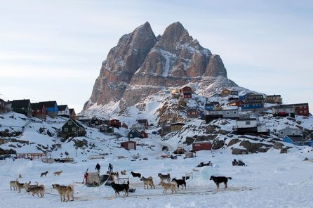
Maine Chapter Board Member, Will Richard, is visiting the area of the northernmost section of the International Appalachian Trail close to Uummannaq, Greenland, the home village of some of the Greenland Chapter’s leaders. Currently, traveling to Greenland is not all that difficult – although it is not cheap. Icelandic Air will fly you from Boston to Iceland, Air Iceland will fly you from Iceland to Ilulissat in Northwest Greenland. Then, Air Greenland will fly you to the north side of the Nuussuaq Peninsula to Qaarsut and then by helicopter over the sea with icebergs floating below to Uummannaq, an island town and to seven small outlying settlements within Uummannaq Fjord.
Uummannaq is located at about 71 degrees latitude , about 300 miles north of the Arctic Circle, which is almost the same latitude as Alaska’s northern-most town, Point Barrow.

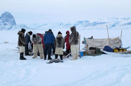
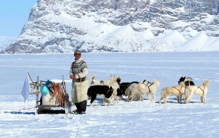
For perhaps a decade now, I have been visiting Greenland – with my wife Lindsay and sometimes solo. For much of that time, I have wanted to travel on Greenland’s sea ice as I have on the ice of Canada’s Inuit Territory of Nunavut. But, a major difference is that ice travel in Nunavut is almost exclusively by snowmobile and komatek (sled) and sea ice on this side of Baffin Bay has become quite limited. In Greenland, ice travel is almost exclusively by dog sledge – but that is apparently changing. In at least a half-dozen previous trips to Uummannaq Fjord, I have planned to be here when there is sea ice. But, with rising Arctic temperatures, there has been no sea ice during my visits in May, June, August, September – even in December and January.

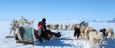
Earlier this year, our good friend and frequent visitor to Maine, René Kristiansen of the Children’s Home in Uummannaq e-mailed me: this is the year for ice. So, as a Research Collaborator with the Smithsonian’s Arctic Studies Center and Research Fellow with the Uummannaq Polar Institute, I am enjoying this now rare opportunity to travel by dog sledge and to enquire about climate change and implications for Greenlandic traditional culture. Faroese Islander Ann Andreasen is Director of both the Uummannaq Children’s Home and of the Uummannaq Polar Institute.
And, there is another piece of this story which has definite local application in Maine. That is the International Appalachian Trail, an idea first advanced by Maine’s Dick Anderson in 1994. With a sister range created in the same tectonic plate event which created the Appalachian range, Greenland’s Caledonide range provides a link to the International Appalachian Trail and across the North Atlantic to Europe . In July of this year, with a party of seven, these Greenlanders will hike from Mt. Katahdin to the New Brunswick border.

In these last few years Greenlanders have not been exactly rare visitors in Maine. A few years ago after meeting René in Uummannaq, he mentioned that a few Greenlanders may be in NYC that fall and that they may visit us in Maine. Well, with two days notice and with a two-bedroom house, Lindsay and I were visited by 14 Greenlanders. Fortunately, good friend Don Hudson and the Chewonki Foundation came to the rescue with bed and board.
Now travel is not only from Maine to Greenland but also from Greenland to Maine, establishing ties of wilderness hiking, of music and film, and friendships.

Mars Hill and Fort Fairfield IAT repair and clean-up

My experience in helping Maine IAT work near the U.S./Canadian border by Walt Guerette (GIS student intern at UMPI GIS Laboratory) (Pictures by Chunzeng Wang)
May 22nd was my first day working in the field with the UMPI GIS Laboratory as a summer GIS project intern. I knew we would be hiking a section of the IAT leading over Mars Hill, but I really didn’t know what to expect. We were accompanied by Justine Cyr, who was also working her first day in the field as a GIS summer intern. After meeting up with Dave and Richard Rand, we drove to the base of Mars Hill, stopping occasionally to put up IAT markers along the road.
After parking Chunzeng’s car at the north end of the Mars Hill section of the IAT we would be hiking, we piled into the bed of Dave’s pickup and ascended First Wind’s access road. My father, as a Project Manager for Reed &Reed Engineering, spent lots of time working on the Mars Hill Wind Turbine project, so I had always been interested. Just getting to ride the access road on our way to the beginning of the trail section was probably the highlight of my day. After a quick detour to repair and clean up the Mars Hill lean-to site, we drove to the beginning of our trail section and began hiking, clearing and trimming the trail and putting signs as we hiked. I used one of UMPI’s Trimble GeoXH GPS units to map the trail as we hiked.
On Friday the 25th, Chunzeng, Dave, and I hiked into the Fort Fairfield lean-to site along the Fort Fairfield section of the IAT US/Canada border trail, accompanied by Kim McCrea who is UMPI OAPI Manager and Gentle Hall Assistant Director, and her dog, Bella. No mapping was done today, but we repaired one sign post and placed another as we hiked, in addition to cleaning up the Fort Fairfield lean-to site. The trail brought us along side the US border markers, which was a first for me. On our drive home, we stopped periodically to place IAT markers along telephone poles accordingly. I consider myself incredibly fortunate to be able to work in these places. From driving around the Mars Hill wind towers to hiking along the U.S. Border, it’s pretty hard to believe that I get to call this “work”.

At the Mars Hill lean-to, Richard Rand, Chunzeng Wang, Justine Cyr, Walt Guerette, and David Rand

Chainsaw Carpentry at Mars Hill lean-to

Walking the IAT First Wind road section

Removing a blowdown from the trail

At the Fort Fairfield lean-to, Chunzeng Wang, Kim McCrea with Bella, David Rand, and Walt Guerette