ALDHA Gathering

Dick Anderson with IAT thru-hikers Mary and Denis Webster

Dick Anderson with IAT thru-hiker Denis Webster (L) and Bill O’Brian (R) former ALDHA Coordinator and Coordinator for 2011 Gathering

Dick Anderson with IAT thru-hikers Joyce and Peter Cottrell "Laurel and Hardy"

Dick Anderson with past ALDHA Coordinator and IAT and ECO thru-hiker JoJo Koby-Burley
Dick Anderson and IAT Chief Geologist Walter Anderson put a couple of thousand miles on their vehicle and represented the International Appalachian Trail at the annual Gathering of the Appalachian Long Distance Hikers Association(ALDHA). The 2010 Gathering was held at Concord University in Athens, West Virginia.
They organized handouts and mounted maps and staffed an information table on Saturday and Sunday. The new map, defining the location of Appalachian domains around the North Atlantic, was the centerpiece of the information display and created lots of interest.
Two hundred , hard core, long distance hikers attended this year’s Gathering. That was a significantly lower number than usual due to a scheduling issue.
Dick and Walter got to renew their friendships with legendary long distance hikers like "Baltimore Jack" ,"Mother Nature’s Son", "JoJo Smiley", "Red Wolf",
"Otto", "Nomad98" , "Mama Lipton", "Wing-Hart" and many others. They also had a chance to talk with Steve Paradis, Chief Operating Officer of the Appalachian Trail Conservancy.
They gave three Power Point presentations on the IAT. Their presentations were focused on the terrains through which the trail passes in the United States and Canada. They also discussed our Chapters in Greenland and Scotland and our new Chapters in Europe. Present developments in Spain and Morocco were also addressed.
Next year’s ALDHA Gathering will be held in North Adams, Massachusetts, only a couple of hundred miles from Portland ,Maine and Boston, Massachusetts.
The Program Coordinator for the 2011 Gathering is Bill O’Brien. Bill is a long-time ALDHA leader and has already been busy making plans for the 2011 Gathering.
He has appointed Dick to be on his Planning Committee. Dick will be keeping IAT Chapters and members up to date as we work towards the October, 7-10, 2011 Gathering.
At the Annual ALDHA business meeting Mike Wingeart was elected ALDHA Coordinator for the next year. For pictures and stories about the Gathering visit www.aldha.org.
On an IAT news note from the Gathering; well known and accomplished, long distance hikers Joyce and Peter Cottrell, "Laurel and Hardy" announced that they were planning a thru hike of the IAT in Prince Edward Island, Nova Scotia and Newfoundland and Labrador in 2011. They have already thru-hiked the IAT from Katahdin to Cap Gaspe. Some will remember that they joined us for the IAT 10th Anniversary celebration at Black’s Lodge in Nictau, New Brunswick, Canada in 2004.
Thanks to Walter who did his usual great job taking pictures.

University of Machias honors Don Hudson with Distinguished Service Awa

Don Hudson delivers UMM commencement speech and receives Distinguished Service Award
MACHIAS, Maine — The University of Maine at Machias awarded 75 degrees during its 2010 commencement ceremony on Saturday at Frederic A. Reynolds Center.
Forty students earned Bachelor of Science degrees, 24 earned Bachelor of Arts degrees, nine were awarded Bachelor of College Studies degrees and two earned Associate in Science degrees at the 99th commencement in the school’s history.
Three students — Nathaniel Jillette of Lewiston, Cody Jourdet of Friendship and Andrew Hayes of New Castle, Del. — received both a Bachelor of Arts and a Bachelor of Science degree. William Cassidy, Class of 1975, received the Distinguished Achievement Award, and 1967 graduate Howard McFadden earned the Distinguished Alumnus Award.
The event was billed as a “waste-free” ceremony, meaning everything was recycled or composted. Even the robes that graduates wore were made of 100 percent recycled material. The commencement speech was delivered by W. Donald Hudson Jr., president of the Chewonki Foundation, who also received the school’s Distin-guished Service Award, and his remarks reflected an environmentalist tone as well.
Hudson gave students a history of his life and experiences, starting with his first climb of Mount Katahdin in 1963 as a 13-year-old and ending with his recent involvement with Chewonki, the Wiscasset-based nonprofit that offers educational programs for youth that focus on the environment.
“In summary, as I look back on my path through life and upon the full spectrum of my work — from the summer of 1966 to now, the impulse to reduce my footprint, my impact, on the planet was unavoidable,” he said.
He then offered what he called the six essential principles of sustainability, which ranged from the understanding that people and nature are inextricably connected to the realization that quality of life is measured in more than material ways.
UMM President Cynthia Huggins had a simple message for students: Take care.
“Take care of this planet and its precious, limited resources,” she said. “Take care of your friends, your families, and the people you encounter on life’s journey. Take care of yourselves.”

Following the Bule and White Plaques

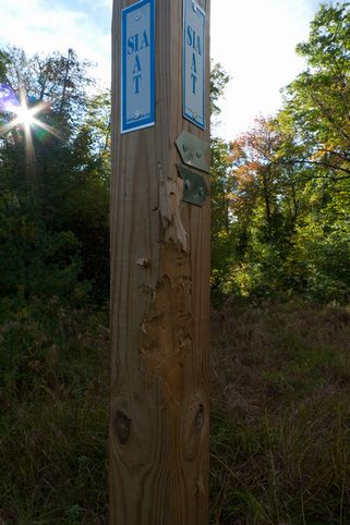
I first saw the little blue and white plaques while hiking along the East Branch of the Penobscot last fall. IAT-SIA they indicated. Then I became obsessed with them. What were they, where did they go?
An online search showed the trail, from Baxter State Park in Maine clear to the tip of the Gaspe Peninsula in Quebec. I was dumbfounded. And then I read that it continued into the other Maritime Provinces, Greenland, and Europe. My next question was: Who created this trail? I wanted to begin hiking it right away.
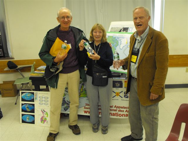
Reaching IAT president and founder Dick Anderson resulted in another half dozen emails coming my way- information from trail volunteers about the sections they maintained. Right away, I sensed a lot of enthusiasm from a diverse bunch of people who seemed delighted that I was interested in their trail.
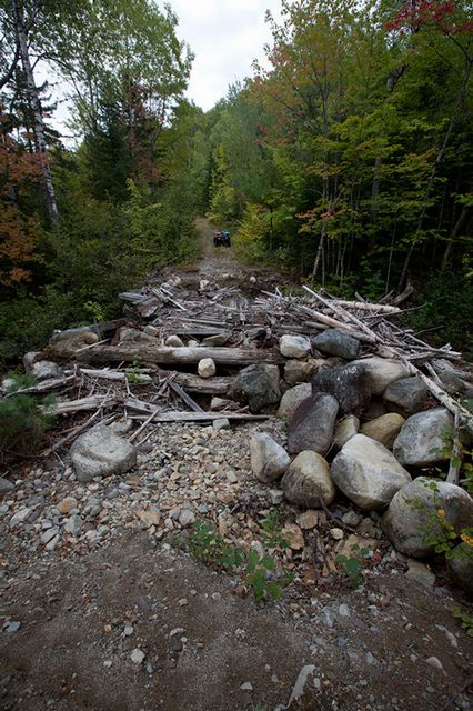
I’m not a strong hiker, I’m on the upper side of sixty, and I usually hike alone. The first thirty miles is pretty remote, beginning on a large clear-cut parcel following old logging roads, miles away from anything. I planned a four-day trip just to check out that section, hiking backward from my vehicle left in a gravel pit near the East Branch. It was a day’s hike just getting to the trail.
On the first day, I came upon a recently constructed log lean-to on the old tote road near the wild and beautiful Wassataquoik Stream. Pretty good start, I thought, especially since it was raining. Continuing in the rain the next day, I walked the 5.5 miles to the start of the trail at the Park border near Katahdin Lake. The little blue and white markers were all there, well visible on posts at every turn. My confidence in the trail got a solid boost.
This summer, I am walking the IAT. The Maine portion is behind me now, though I veered from the path as I approached Canada since I had a place to rest and revamp for a few days. The little blue and white plaques were my beacons for a couple weeks, those little signs of recognition that said, yep, you’re on the trail. Each one reminded me of the hard work done by a dedicated group of volunteers over the past decade, seeing through their dream of a through-trail along the entire Appalachian spine.
What is a through trail? It’s a trail where a person can begin walking and actually go somewhere. Some people bomb through the trail, their goal a far-away destination. Others, like myself, tend to stroll, though I don’t know anyone else who is as slow as I am.
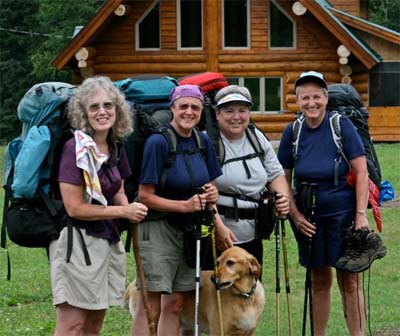
I took six days to cover the first thirty miles, losing the trail due to inattention in rain and thick mosquitoes, but finding it again after a seven mile detour which was actually quite pretty. The only people I saw in six days were the IAT trail crew, out there cutting and hacking brush in the same rain and bugs I had started out in. Sharing a lean-to with them, I enjoyed homemade fish chowder versus my own dried store. I should add that most of these fellows are pushing seventy, even eighty years old.
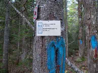
The rain cleared for my climb up Deasey Mt. followed by Lunksoos with the reward of another lean-to looking straight onto Katahdin. Lingering at the Grand Pitch lean-to, I spent an afternoon at the brink of the thunderous falls.
The first thirty miles of the IAT passes through a sanctuary where no motorized vehicles are allowed (except for maintenance). It is truly another world full of wildlife, where bear and moose sitings are common. The IAT folks were very pleased to gain permission as well as support to build their trail through this beautiful land parcel skirting two major tributaries of the Penobscot watershed.
Beyond the sanctuary, the trail follows rural roads with a couple shelters along the way. The shelters sit high up on Aroostook County farms. One landowning couple had placed a camper near the shelter for hikers to use in inclement weather, offering coffee, a shower, and a whopping breakfast the next morning.
Soon I was on the multi-use rail-trail which provided three days of flat, easy walking down a shady lane, much appreciated in the sweltering heat of July 4th weekend. I had gotten off the trail hoping to get a hot dog and perhaps an ice-cream cone (treats I would never eat at home), when a picnicking couple offered me a steak fresh off the grill.
As I was about to pitch my tent in a grassy spot near the trail, indicated as an optional campsite, an ATVer suggested I go a little further off the trail to a private campground. The grass was mowed. There were fire pits and picnic tables along a tumbling, clear stream. All I needed was permission from the owner. I was welcome, he said, bringing a stack of wood later for a fire. But I had already joined other campers, friends of the landowner whose hospitality we all shared, to enjoy some miniature fireworks.
On the trail again, I opted out of the climb up Mars Hill where I was promised a spectacular view from the lean-to at the top, sticking with the easy rail trail most of the way to Caribou.
I’m not a purist. A purist will backtrack if he or she misses any part of the trail, to walk every inch of it. It’s part of the integrity in saying, “I hiked the IAT”. I call myself a convenience hiker. If the trail is convenient and fun, I’ll hike it. If not, I’ll find my own way. The offer of a rest for a few days is reason for a detour. But I missed the little blue markers which seemed to say hello from the founders of this trail and the volunteers who have worked so hard to mark and maintain it, like a bit of encouragement along the way.
Tomorrow, I’ll be on the trail again, following my own route along the pretty Aroostook River to Fort Fairfield and the border. From there I’ve had to make a decision. Continue as a through-hiker across the northeastern part of New Brunswick and on to the rugged Chic-Chocs of the Gaspe Peninsula, or take a bus. I’m hopping the bus- straight to Prince Edward Island followed by Nova Scotia, to hike the IAT in those beautiful provinces. I’m a segment hiker, mixing up the segments, no less, to suit my own whims.
Already, half a dozen people from the two provinces have emailed me with a welcome, telephone numbers, and information about their portions of the International Trail. Some provinces provide online step-by-step instructions with maps as the Maine chapter does; others refer a hiker to government-funded guidebooks available for purchase. Some have free shelters as Maine does, others require a pass fee for shelter use, and others provide tourist information of places to stay. Every province has something different to offer from sheer wilderness and rugged mountains to seaside marshland and pretty little farms and villages brimming with culture. I’ve opted for the latter in the summer’s time remaining.
Like the trail folks, I have a dream also. If all goes well this summer, I hope to hike the ancient ways of Ireland next year where I might well see the familiar blue and white plaques if the IAT plans go forward. And from there, who knows. Did they say Spain and Morocco

Fall 2010 Trail Work Trip Report

On Wednesday, 9/22/10, Herb Hartman, Bill Duffy and his dog Trip, and Dave Rand with his ATV and wagon, arrived at Bowlin Camps (www.bowlincamps.com), an extremely convenient and pleasant base out of which to operate, at noon. This dedicated little group crossed the East Branch of the Penobscot on the suspended snowmobile bridge and headed south on the IAT. Additional IAT tags were nailed up, a directional sign post was placed on the trail at the junction of the former Little Spring Brook Road and the former Eagle Lake Road, encroaching alders were cleared, trail marking (tags and ribbon) were switched from leading over the rotten, collapsed bridge to the new ford site at Little Hathorne Brook, and the sign post on the Orrin Falls/Messer Pond Road checked. Walter “Cookee”, Anderson, Dick Anderson, and Wilfred Richard arrived at Bowlin later in the day and went to work northward, toward Grand Pitch shelter, clearing trailside brush. That evening, at our camp, “No Aces”, Walter’s renowned four bean salad accompanied Dick’s beef stew.
Thursday, Bill and Trip, Herb, and Will set out on the trail toward the Grand Pitch shelter, where they arrived two hours later after having chain sawn numerous blowdowns, lopped encroaching brush, checked a bear-gnawed sign post to which the added a directional and mileage sign. Dick and Dave followed on the ATV lopping and pulling up fir seedlings within and along the trail. Later in the day, Dave, Bill and Trip, and Will ATV’d south to work on the ford at Little Hathorne Brook.
That evening there was more four bean salad and Walter’s spaghetti with big, really big, meatballs. The new owner of Bowlin Camps arrived from New Jersey with his wife and was pleased the group was staying at the camps, which he is significantly enhancing, and hear of the IAT, which he enthusiastically supports.
It was agreed all the intended trail work had been accomplished on Friday and the party left in the rain after another of Walter’s hearty breakfasts.

After a hard days work

Bears!

Little Hawthorne Brook

New Trail Sign

Ladies Hike the IAT

Latona Torrey, Joan Hildreth, Pat Huntley and Linda Ives
In case you are wondering, “where are they now?” here is a quick update. We departed from Maine, July 6, and began hiking with two other friends in Perth Andover, New Brunswick. We had decided to skip the 100-mile section of the IAT in Maine and go for the New Brunswick/Quebec sections because of time constraints and a strong desire to make it to Cap Gaspé at the point of land where the Appalachian Chain “drops” into the Atlantic. We planned two months to hike this section.
We traveled through New Brunswick being treated like celebrities, or long lost friends, by the local people in the towns of Plaster Rock, Nictau and Saint Quentin. One of our friends developed severe blisters and we stopped in Kedgwick, first to see a doctor for advice, and then at a camp along the Kedgwick River for some R&R for her feet. Recuperation was slow, and she decided to get off the trail.
At this point, now three of us remaining, we had a choice of hiking, or traveling 65 miles via canoe on the Restigouche River – a pristine salmon river – and chose this opportunity. We paddled about 22 miles each day and camped along the river, often seeing the salmon swimming below us, or leaping above the river, and once being landed by an accomplished fishermen. That one was well-over three feet long. The end point of this river experience was floating into Matapedia, Quebec.
Here, we believed we would leave the road walks and flat rails-to-trails of New Brunswick and enter the more challenging wooded, mountainous hiking of Quebec. How true that would prove to be. We hiked out of Matapedia with full-packs – about 35 pounds with food, tent, clothes and the other essential to remain safe and “comfortable” as we journeyed. The shelters that we found during the first few days were beautiful cabins called refuges. The first was called Le Turcotte and sat on the edge of a beaver pond. We enjoyed the beaver family’s work and play all evening.
The second and third day we spent at the Le Corbeau Refuge nestled deep in the forests of the Lower Matapedia Valley. Here we waited out a furious rainstorm and realized that we had not seen another soul in three days. Latona’s famous quote as we anticipated going on was “There is nobody out there!” At this point we all realized that we weren’t comfortable at our ages to continue the hike in this wilderness area, so we decided to hike out a side trail and head to the national parks that were ahead of us and still part of the IAT.
The side trail turned into a nightmare. Latona fell doing a couple of rolls off the side of the mountain, bruising her lip, twisting her glasses, and damaging her left knee. We managed to get out to the road, after seven hours of very difficult hiking, and much pain for her. Eventually, made it to the next town. Here we planned to get a bus to the Gaspé National Park and go on after some rest for her. In this town, our other hiking companion got word that she needed to return home for a family emergency.
Now we were just the Daicey Duo again. It was the end of July when we entered the Gaspé National Park. We stayed in another refuge, and then hiked two days in the Chic Choc Mountains but soon realized that Latona’s knee was not happy going up and down mountains. Another decision. What would we do now?
We did not want to give up the trip so we decided to road walk the edge of the Gaspé Peninsula until we would arrive at Forillon National Parc and Cap Gaspé. We used the bus when the knee got too bad, and rested in motels in between. Walking along the St. Lawrence Seaway, sighting whales and seals, and enjoying the many, many Northern Gannets diving for their food was thrilling.
The final hike into Cap Gaspé was beautiful and we stood by the lighthouse and had our picture taken by the two signs that describe both the Appalachian Trail and the International Appalachian Trail.
We arrived home on August 23. Even though we spent more time in motels, and ate more meals in restaurants than we planned, we had an amazing seven-week experience filled with kind “trail angels” all the way, breathtaking sights, and the realization that we can still carry our backpacks – at least for a few more miles. Yippee!!
Linda Ives